AGU 2024 Session on Compound, Consecutive, and Cascading Events
By Helena Garcia, University of North Carolina at Chapel Hill
Conveners: Alejandra Enriquez, Helena Garcia, Mona Hemmati, Md Mamunur Rashid, Colin Raymond, Marleen de Ruiter, Cass Rogers, Antonia Sebastian
In Washington, DC on December 12-13, we convened a session titled “Compound, Consecutive, and Cascading Events: Challenges for Risk Assessment and Management” within the Natural Hazard section of the American Geophysical Union (AGU) 2024 conference. Presentations and posters in this session focused on multi-hazards and their interrelationships, from triggering to compounding, as well as resulting impacts across different sectors. The need to shift from single to multi-hazard risk assessment was a key motivator for convening this session, especially as instances of multi-hazards are expected to become more frequent and intense.
Poster Session:
The poster session showcased 16 diverse studies, spanning different multi-hazard topics and scales from local to global. Many posters focused on compound flooding risks, including efforts to disentangle the different processes of compound flooding (e.g., storm surge, extreme precipitation) as well as methods for rapid identification of compound flooding using satellite imagery. A number of case-studies highlighted specific events, such as Typhoon Gaemi (2024) and flood-triggered landslides and debris flows in North Vietnam. Several posters examined the impacts of multi-hazard events—typically flooding combined with another hazard—on local businesses (via business interruptions), utilities (e.g., water purification plants in Japan, power outages in Florida, USA), and infrastructure (e.g., road network disruptions, bridge failures). Some posters explored hazard events over time, addressing topics like the temporal clustering of storm surge, event-based flood exposure mapping, and comparing methods for detecting single versus compound hazard events. Finally, a few posters focused specifically on compound dry and hot events, examining the uncertainty of future projections and techniques for characterizing historical occurrences. Overall, the poster session contained a wide mix of multi-hazard topics—from characterization to challenges—and the poster hall was busy with conversations, questions, and feedback!
Oral Session:
The oral session featured seven presenters, focusing on a range of multi-hazard topics, from post-fire floods to compound heat-tropical cyclone events. The session kicked off with our invited speaker, Dr. James Doss-Gollin from Rice University, who spoke about leveraging machine learning and artificial intelligence (ML/AI) in urban flood research and management. He emphasized the importance of embracing uncertainty in decision-making, noting that although ML/AI can improve flood models, they are not perfect solutions—uncertainty will remain a key challenge in multi-hazard management!
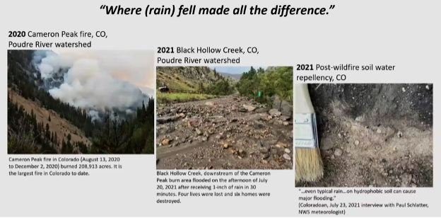
The next two talks focused on post-fire flood risks. The first talk showed the spatial distribution of post-fire flood risk in Riverside, California, and the second talk highlighted a method for improved runoff predictions following fires using a measure called sorptivity, which describes water repellency in soils. The following talk explored extreme value analysis (EVA) of tropical cyclones and extratropic cyclones, stressing the need to separate EVAs by storm types to avoid low-biased estimates. This presentation also included a case study in New York City, reporting that the most intense tropical cyclone rain and surge events have the most potential for compounding.
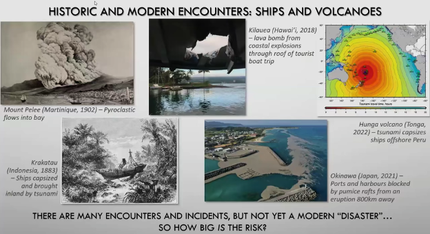
The next presenter shifted to focusing on global shipping vulnerabilities to marine and coastal volcanic hazards. This talk highlighted how volcano hazard maps rarely extend offshore, even though there are historical examples of pyroclastic flows and pumice blockages impacting ports, as well as eruption-triggered tsunamis capsizing vessels. The maps presented identified high-risk areas, such as the Mediterranean Sea and the Sea of Japan.
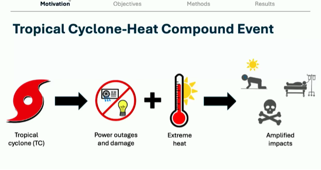
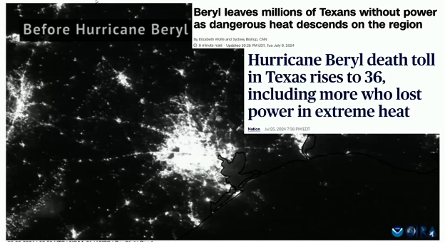
Our final two presenters examined compound events involving heat and tropical cyclones globally, as well as heat and extreme precipitation in the US southeast. In the US southeast, both heat-preceding-precipitation and heat-following-precipitation events were identified and trends showed that both these kinds of multi-hazards have increased 5-fold since 1940. From a global perspective, there are few observations of heat events following tropical cyclones, although there are recent notable examples like Hurricane Beryl (2024) in Houston, Texas. In this final presentation, global climate models (GCMs) were leveraged to see how well they capture tropical cyclone-heat hazards. When compared to historical observations (1980-2020), the models found fewer events but identified similar hotspots in Mexico, India, East Asian and northern Australia.
We had great questions from the audience throughout our oral session and were especially grateful to all who showed up and participated bright and early on Friday morning at AGU!
Post edited by Cassandra Rogers and Andreia Ribeiro.